|
|
|
| Subscriptions click here for 20% off! | E-Mail: info@rangemagazine.com |
|
TANK TRAPS
|
||||||
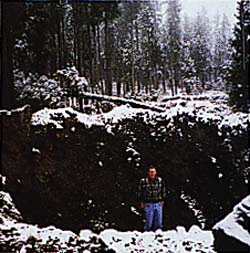
Some might chalk his accident up to carelessness, inexperience, or wonder if he and his three friends were illegally riding on closed forest roads, but none of these scenarios was the case. In fact, like many Idahoans, Commissioner Robson is an avid snowmobiler with plenty of alpine experience and was traveling on a road closed only during the summer. The important question the public has asked since is why the Forest Service has intentionally ravaged our public lands, restricted access to recreationists, sportsmen, loggers and search and rescue teams, and then left unmarked traps hidden under the snow that could kill snowmobilers. For the last eight years, the forest revision management plan for the Targhee National Forest, which borders the southwestern boundary of Yellowstone National Park in eastern Idaho, has become a battleground for environmentalist groups, loggers and recreationists, attracting the attention of the entire region. The issue at stake is no small matter. In an age when public land restrictions grow by leaps and bounds each year, westerners have watched as the federal government unilaterally put a stranglehold on the very lands their livelihood and lifestyle depend upon. When the revised forest management plan was first drawn up, citizen involvement groups were encouraged by the approach Jim Caswell, the forest supervisor at the time, was advocating. He had hired Dr. Bill Shands, the country’s foremost expert on forest planning and public involvement, to begin an open dialogue between the public and the Forest Service. The results of the Caswell-Shands dialogue formed the basis of the draft standards and management prescriptions of the forest, but in 1993 public involvement changed dramatically when the Clinton administration took it over. During the next four years, communication between the government and rural communities began to dwindle as citizen involvement groups realized their importance to the forest supervisors. The county commissioners of the six counties that touch the Targhee Forest even took the unusual step of including an advisory ballot on the May 1996 primary ballot, allowing people to choose between the Citizens For User Friendly Forest’s (CUFF) alternative and the Forest Service’s preferred alternative. The people supported the CUFF alternative by 78 percent, but the management plan did not include their suggestions. Instead, the plan mandated tough road and trail density standards both in and out of the grizzly bear management units and three large sections of the Targhee closed to preserve grizzly bear habitat. It also counted a single track trail where motorized use was allowed as having the same impact on wildlife as a federal highway, but the most flagrant red flag of all was the arrogant "closed unless posted open" policy which changed public land into the King’s Forest. In essence, the federal government closed the 1.8 million acres which make up the Targhee without considering local input. The plan struck at the heart of the western way of life, and directly opposed 100 years of public land law protecting the average citizens’ right to access their land for a variety of reasons. This is called a multiple use policy, and it is incorporated into the guidelines for federal land policy management. However, the Targhee Forest Plan moved away from the multiple use access by forcing more road closures and doing less road maintenance and construction than ever before. As a result, the regional office received 1,276 appeals to the travel plan from local groups and communities. Their appeals were granted, and the Targhee officials were forced to go through another travel plan process that gave the opportunity for public input and comment. Even so, they kept the same inflexible plan. At this time, concerned citizens turned again to their elected officials, including the Idaho delegation, for help. All of the state legislators from eastern Idaho signed a letter opposing the closures, and the delegation met frequently with the Targhee Forest Supervisor, Jerry Reese, as well as U.S. Forest Service Chief Mike Dombeck to ask them to work with the community and address their concerns before proceeding with the plan. Reese stated that the whole management plan would have to be reopened to permit any change, and that he was obligated to close the roads due to the road density standards included in the forest management plan. Not only did Reese close all the roads and gate them, but he then took steps to obliterate them throughout the bear management units. He spent over $300,000 in the summer of ’98 to destroy nearly 400 miles of roads by placing 6- to 10-feet high tank traps in the roads, and ripping the road surface to a depth of two to three feet. To date, the Targhee National Forest has yet to produce a site- specific NEPA document even though the Forest Service’s own documents say it will complete such an analysis before a road is closed. The Targhee Forest managers have stated these public access restrictions are to protect the grizzly bear and elk in the area and to reduce soil erosion. Elk populations, however, are at an all-time high and are doing "terrific" according to the Idaho Fish and Game Department. Likewise, grizzly bear are expanding outside the recovery area into new habitat and could possibly be delisted from the endangered species list. On the other hand, the soil erosion caused by obliteration has contributed a high silt content and endangered the fragile bull trout habitat in the area’s rivers and streams. Last September, Teton County passed an emergency ordinance that temporarily stopped the earth moving equipment from completing the obliteration in that county. About 22 roads remain to be obliterated, but because a civil suit is pending by the Blue Ribbon Coalition and CUFF, the Forest Service agreed to stop the work for the season. Unfortunately, the roads already destroyed have little chance of being restored beyond erosion repair, but the Idaho delegation will continue to ask the federal government to work with the communities in the area and responsibly manage the land. We believe that the best solutions to western land management come when all interested and affected parties are at the table. Any management plan should address the environmental concerns, but should also take into consideration the economy of the communities dependent upon the resource. These lands are public, not private, and a management plan based on a King’s Forest philosophy cuts against the grain of western living and livelihoods. * * * End
|
|||||||
|
To Subscribe: Please click here for subscription or call 1-800-RANGE-4-U for a special web price Copyright © 1998-2005 RANGE magazine last page update: 04.03.05 |